makeattribspec
Create attribute specification
Description
attribspec = makeattribspec(S)kmlwrite,
wmmarker, wmline, and
wmpolygon functions based on the vector geographic features stored in
S.
The kmlwrite function creates an HTML table from attribute fields.
The first column of the table includes attribute labels and the second column includes
attribute values as text. Use an attribute specification with the
kmlwrite function and Description name-value
argument to specify which attribute fields to include in the HTML table and the format of
the attribute values.
When you plot features using wmmarker, wmline,
or wmpolygon, you can view feature balloons with attribute information
by clicking on features. Use an attribute specification with wmmarker,
wmline, or wmpolygon and the
Description name-value argument to specify which attribute fields to
include in the feature balloons and the format of the attribute values.
Examples
Create Attribute Specification
Import a shapefile representing tsunami events reported over several decades, tagged geographically by source location, as a geospatial table. Create an attribute specification from the table.
GT = readgeotable("tsunamis.shp","CoordinateSystemType","geographic");
attribspec = makeattribspec(GT)
attribspec = struct with fields:
           Year: [1x1 struct]
          Month: [1x1 struct]
            Day: [1x1 struct]
           Hour: [1x1 struct]
         Minute: [1x1 struct]
         Second: [1x1 struct]
       Val_Code: [1x1 struct]
       Validity: [1x1 struct]
     Cause_Code: [1x1 struct]
          Cause: [1x1 struct]
         Eq_Mag: [1x1 struct]
        Country: [1x1 struct]
       Location: [1x1 struct]
     Max_Height: [1x1 struct]
       Iida_Mag: [1x1 struct]
      Intensity: [1x1 struct]
     Num_Deaths: [1x1 struct]
    Desc_Deaths: [1x1 struct]
Remove all attributes from the specification, except for the attributes describing the maximum height, cause, year, location, and country.
desiredAttributes = {'Max_Height','Cause','Year','Location','Country'};
allAttributes = fieldnames(attribspec);
attributes = setdiff(allAttributes,desiredAttributes);
attribspec = rmfield(attribspec,attributes)
attribspec = struct with fields:
Year: [1x1 struct]
Cause: [1x1 struct]
Country: [1x1 struct]
Location: [1x1 struct]
Max_Height: [1x1 struct]
Rename the Max_Height attribute to Maximum Height and highlight each attribute label in bold font.
attribspec.Max_Height.AttributeLabel = "<b>Maximum Height</b>";
attribspec.Cause.AttributeLabel = "<b>Cause</b>";
attribspec.Year.AttributeLabel = "<b>Year</b>";
attribspec.Location.AttributeLabel = "<b>Location</b>";
attribspec.Country.AttributeLabel = "<b>Country</b>";
Add Meters to the format of the maximum height attribute. Set the format of the year attribute to include no decimal places.
attribspec.Max_Height.Format = "%.1f Meters";
attribspec.Year.Format = "%.0f";
Export the selected attributes and tsunami source locations to a KML file.
kmlwrite("tsunamis.kml",GT,"Description",attribspec,"Name",GT.Location)
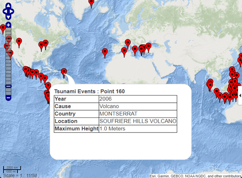
Display Marker Overlay Using Attribute Specification
Import a shapefile representing tsunami events reported over several decades, tagged geographically by source location.
GT = readgeotable("tsunamis.shp","CoordinateSystemType","geographic");
Create an attribute specification for use in the feature balloons. Modify the specification so that it defines a table of values, including year, cause, country, location, and maximum height. The attribute specification defines the format of the expected value for each field.
attribspec = makeattribspec(GT);

desiredAttributes = ...
       {'Max_Height','Cause','Year','Location','Country'};
allAttributes = fieldnames(attribspec);
attributes = setdiff(allAttributes,desiredAttributes);
attribspec = rmfield(attribspec,attributes);
attribspec.Max_Height.AttributeLabel = "<b>Maximum Height</b>";
attribspec.Max_Height.Format = "%.1f Meters";
attribspec.Cause.AttributeLabel = "<b>Cause</b>";
attribspec.Year.AttributeLabel = "<b>Year</b>";
attribspec.Year.Format = "%.0f";
attribspec.Location.AttributeLabel = "<b>Location</b>";
attribspec.Country.AttributeLabel = "<b>Country</b>";
Create a web map with a base layer containing ocean details. Add the marker overlay. Display the table data you specified in the attribute specification by selecting a marker.
webmap("ocean basemap");
wmmarker(GT,"Description",attribspec,...
	     "OverlayName","Tsunami Events")
wmzoom(2)
Input Arguments
Output Arguments
Version History
Introduced before R2006aYou can also select a web site from the following list:
Americas
- América Latina (Español)
- Canada (English)
- United States (English)
Europe
- Belgium (English)
- Denmark (English)
- Deutschland (Deutsch)
- España (Español)
- Finland (English)
- France (Français)
- Ireland (English)
- Italia (Italiano)
- Luxembourg (English)
- Netherlands (English)
- Norway (English)
- Österreich (Deutsch)
- Portugal (English)
- Sweden (English)
- Switzerland
- United Kingdom (English)